結局、駐車場何処止めたは、レンタルサーバがあれば、解消できた。
通常のphpであれば、簡単にできるようなので・・? (´・ω・`)。
と言うか、使えたのでザックリ作成
https://dev.w3.org/geo/api/spec-source.html
こんな感じでスマートフォンの画面にショートカットを作成
セキュリティは、送信元サーバとリファがあれば問題なし。
不正アクセスも、本サーバで無いと動作しないようにするのと、できれば自分の家族分のIP エリアを書き込んで置けば事足りる。
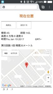
enableHighAccuracy; この精度は、ハードウェアGPS A-GPS搭載なら上げたほうがよりフィックスしやすい大体10m程度だけど5m程度
accuracy;
altitudeAccuracy;は、高度の精度もキャッシュから、比較するようにすると、立体駐車場や精度を把握できる。
立体駐車場は平均2-2.5m/階+梁下0.50程度と考えてcomboboxで階数計算で計算させても良いかな?写真のほうがマシかな?
後は、精度上がるまで、自動更新だけど精度が悪ければマップを自分で操作して、最後はメールで送信。
続きを読む 駐車場は何処止めたの?は、やっぱり自前で →
地盤の状態を簡単に調べられる「地盤安心マップ」と「地盤カルテ」ですと何処まで行くんや?
土地を購入する時や家を建て替える時に気になる“地盤”の診断書。
地盤の診断書的な状態を簡単に調べられるサイトが、地盤ネットホールディングス株式会社が提供する「地盤安心マップ」と「地盤カルテ」ってほほう。
It easier to examine the state of the ground as a “ground peace of mind map,” “ground medical records“
Medical certificate of anxious “ground“ when you rebuild a time and homes to buy the land.
Site that is easy to examine the medical certificate state of the ground have been provided by the ground net Holdings Co., Ltd. as the “ground peace of mind map” is “ground medical record.”
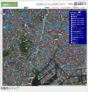
「地盤安心マップ」は、地図上で簡単に地盤の状況を調べられるサービスらしい。
地図の上に地理院地図の航空写真や標高マップ、日本シームレス地質図、土砂災害危険箇所マップ、地震動予測地図、自治体液状化ハザードマップ、災害履歴図、避難所データなどさまざまな情報透過して見れるすぐれもの。
“Ground relief map”, the service that is easy to check the status of the ground on the map.
Aerial photographs and elevation map of the Geographical Survey Institute map on top of the map, Japan seamless geological map, landslide hazard map, seismic hazard map, municipality liquefaction hazard maps, disaster history view, watch and a variety of information transmission, such as shelter data . 続きを読む 日本の地盤の状態を簡単に見れるシステム公開! →
最低限の情報 A minimum of information