
Yahoo!地図、北海道と岩手県の「道路通行実績情報」提供開始しました。
今回の台風災害は非常に困難な状況です。農作物の被害から人的被害多大です。
地方自治体は、10日以上不眠不休で対応されています。
それでソフトパワーが、また日本が発動しました。
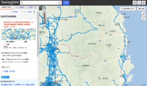
台風10号による浸水被害エリアで実際に通行できた道路を表示
“Yahoo! map”, we have started providing “road traffic performance information” of Hokkaido and Iwate Prefecture.
This time of the typhoon disaster is a very difficult situation. It is a great deal of human suffering from the damage of agricultural crops.
Local governments, has been supported by more than 10 days without sleep and rest.
So soft power, but also Japan was triggered.
Display the actual traffic can road in flood damage area by typhoon No. 10
以下がリンクです。
本田技研工業株式会社の「インターナビ」搭載車両から収集したデータに基づき、過去4時間に実際に通行できた実績のある道路を、地図上に青色で表示。
道路の浸水被害の大きかった地域において、被災地域内での移動や支援・救援に向かう際の参考情報として提供するもの。
Yahoo!地図のPC版・スマートフォン版サイトで閲覧可能。
iPhone版・Android版アプリには対応していないないそうです。
Based on the data collected from the “Inter-Navi” a vehicle equipped with the Honda Motor Co., Ltd., a road that actually track record that could pass in the past four hours, displayed in blue on the map.
In the greater was the region of the flood damage of the road, it shall be provided as reference information when directed to move and support and relief in the affected areas.
Available on PC version smart phone version of the site of Yahoo! map.
It seems there is no that does not correspond to the iPhone version · Android version of the app.