災害対策や公共サービスなどにおけるGISや位置情報技術の利活用でGPS/GNSSやビーコン、Wi-Fi、音波や地磁気による測位技術などを活用して、山の遭難事故を防止する取り組みが模索。
GPS / GNSS, beacon, Wi-Fi, positioning technology based on sound waves and geomagnetism etc. by using GIS and location information technology in disaster countermeasures and public services etc Try to exploit efforts to prevent mountain distress accidents.
山は携帯電話の電波が届かないエリアで、電源が確保できないのが多く電池切れを心配して
スマートフォンの電源を切っている人もいるらしい。
Mountain in the area where radio waves of the mobile phone does not reach,Power supply can not be secured many times, worrying about running out of batteries
Some people turn off the smartphone.
その状況を踏まえて、いかに登山者の位置情報をリアルタイムに把握し、道迷いや滑落といった事態が発生した場合に迅速に遭難者を捜し出せるか日夜考えているらしい。
本当に日本的と言うか、
Based on that situation, how to grasp the position information of climbers in real time,
In the event of a situation such as stray doubt or slipping down It seems that he / she thinks that he / she can find the victim quickly.
It is truly Japanese-style
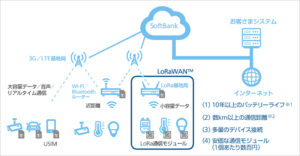
株式会社博報堂アイ・スタジオの「TREK TRACK」のシステムは、低消費電力でIoTデバイスとの連携を実現する無線通信規格「LPWA(Low Power Wide Area)」の1つ「LoRaWAN」を活用して登山者の位置情報を記録できるらしい。
The system of “TREK TRACK” of Hakuhodo eye studio,Realize cooperation with IoT devices with low power consumption One of the wireless communication standards “LPWA (Low Power Wide Area)” “LoRaWAN” It seems that you can record the location information of climbers by utilizing it.
実証実験を2016年10月19日、長野県の北八ヶ岳にて実施
Field trial conducted on October 19, 2016 at Kita Yatsugatake, Nagano Prefecture
http://internet.watch.impress.co.jp/docs/column/chizu3/1037368.html
LoRaWAN™はLPWAのネットワーク通信技術、920MHz帯域を利用のキットで実現とな
LoRaWAN ™ is realized with LPWA’s network communication technology, a kit that uses the 920 MHz band
TREK TRACK
http://trektrack.jp/ja/