海上保安庁が、明治期から大正期ごろにかけての古い海図の提供してほしいと探しています。
関東大震災で全国の海図の原版と目録を焼失し、今も多くの海図が失われ、歴史的史料として貴重なため、心当たりがある人からの連絡を待っているようですよ。
古い海図の収集と電子化による保存公開を行っている海上保安庁海洋情報部が昨年9月に情報を募ったところ、
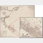
今年1月になって愛知県の男性が東京湾から和歌山・串本にかけての海域をカバーする海図を提供されたとの事。
「古い海図は海岸線や港湾施設の変遷が分かることから意義深い。特に戦前に刊行された海図の情報があれば寄せてほしい
問い合わせは、同部企画課電話03(3595)3620ですと
版権ごめんなさい
I am sorry for copyright
Japan Coast Guard, we are looking for and want to provide the old charts of the Taisho period around from the Meiji era.
The Great Kanto Earthquake burned down the original charts and catalogs of nationwide charts,
Even now many of the chart is lost,
Because it is precious as a historical historical material,
It seems that I am waiting for a message from somebody who I know.
We are collecting old charts and saving them by digitization
The Japan Coast Guard Ocean Information Department asked for information in September last year,
In January of this year a man in Aichi Prefecture provided a chart that covers the waters from Tokyo Bay to Wakayama / Kushimoto.
“The old sea chart is meaningful as it shows the transition of coastline and port facility.
Especially if you have any information on the charts that were published before the war, let me know
For inquiries,
“Planning Section” Telephone 03 (3595) 3620
http://www1.kaiho.mlit.go.jp/KIKAKU/hurui-kaizu.html